Lime Kiln Lighthouse

Lime Kiln Lighthouse on the west side of San Juan Island, Washington

Lime Kiln Lighthouse on the west side of San Juan Island, Washington

Lime Kiln Lighthouse on the west side of San Juan Island, Washington

Lime Kiln Lighthouse on the west side of San Juan Island, Washington

Lime Kiln Lighthouse on the west side of San Juan Island, Washington

Thursday, May 30, 2013

No. 187 Redmond Washington Historic Yellowstone Trail / Red Brick Road

Yellowstone Trail
Redmond, WA

MAP IT

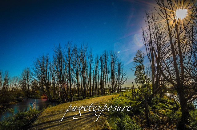
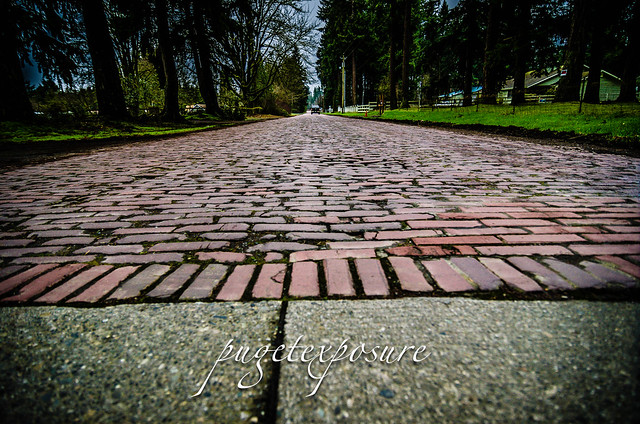
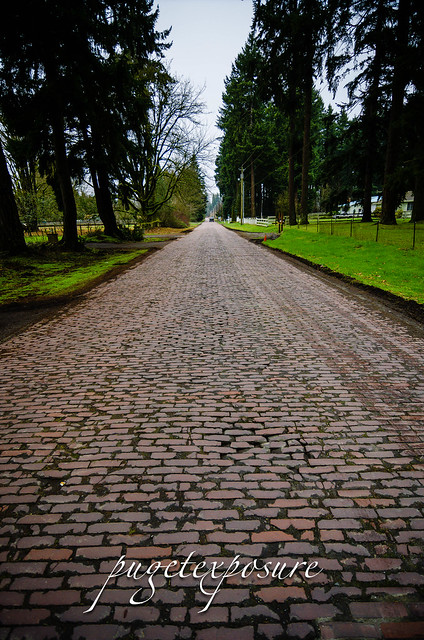
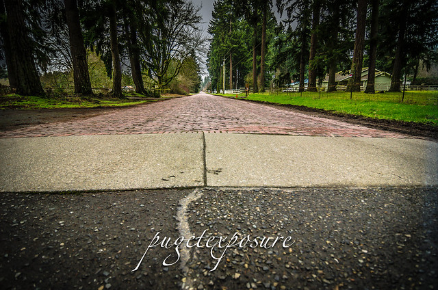
This historic 1 mile long portion of 196th Ave NE just east of Redmond, WA still has the original 1913 hand laid red brick pavers that were once part of the Yellowstone Trail that connected Seattle to Yellowstone and continued on to Boston, Massachusetts on the east coast.
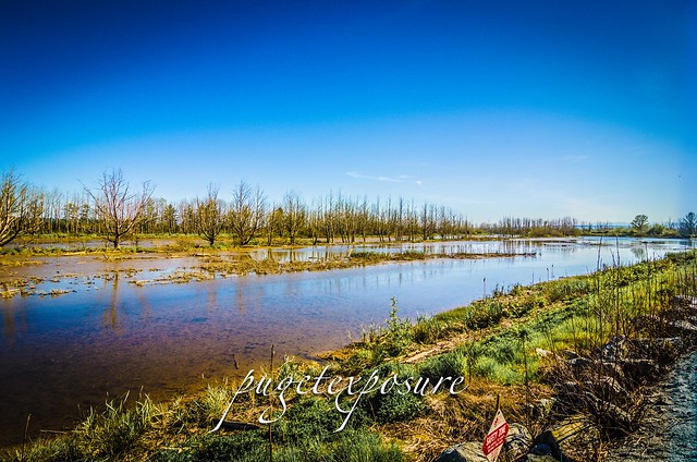
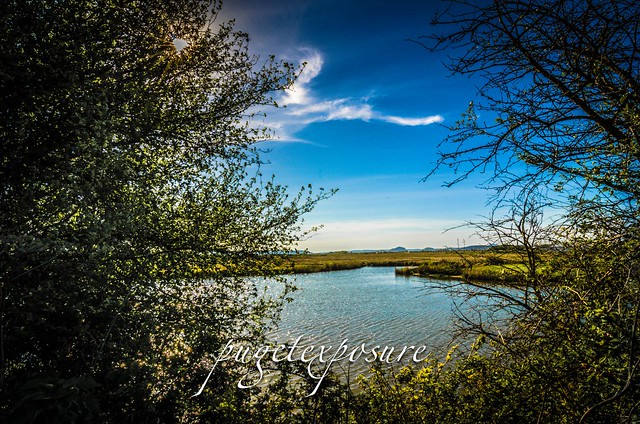
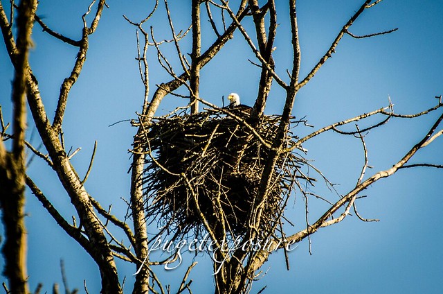
Built during the horse drawn carriage era and the beginnings of the automobile revolution the brick roadway is one of the few sections along this interstate roadway in original condition. This portion of 196th Ave NE runs between some famous horse farms and sheep farms and various private estates. Towards the north it opens up to a marshland area where hawks, falcons and bald eagles can be scene if you know what time of day and year to look for them.
The posted speed limit is 25mph and for its time a brick road did offer a speedy alternative to deep rutted and muddy dirt roads. Even with today's modern automobile capable of much faster speeds the bumpy road will test your car seat cushioning and shock absorbers as you rumble across the road way.


Red Brick Road


Red Brick Road

Red Brick Road
Gear Used:
 
lens rental Washington State travel, Washington State travel, Washington Destinations, Photography, Photography spots, best things to do in Seattle, Best things to in Washington State, Washington Tourism Alliance, Washington State Tourism board, recommendations, recommendations for things to see in washington state, things to do in washington state, things to do in seattle, things to do in Tacoma washington, Washington Photographers, Washington nikon shooters, best seattle photography, washington exploration, experience washington, what to do while visiting seattle, seattle top attractions, seattle food, Space Needle, Explore Washington State, Puget Exposure Photography, Puget Exposure, Road Trips through Washington State, Weird Washington, King County, Snohomish County, Seattle, Everett, Tacoma, Kent, Redmond, Kirkland, Washington Sunrises where and when, Washington State Weather, Redmond Washington, Yellowstone Road,Yellowstone Trail, Seattle to Boston highway, Redbrick Road Redmond Washington, Historic Roads in Washington, Historic Road in Redmond

Friday, May 17, 2013

No. 186 A different angle on Seattle Skyline from below Interstate I-5


North Passage Point Park
600 NE Northlake Way
Seattle, WA 98105

MAP IT 

North Passage Point Park is a small 0.8 green space on the north shore of Lake Union directly under the I-5 Ship Canal Bridge that spans the Portage Bay Canal. For it being tucked away and its small size it makes up for with views of Queen Anne, Space Needle and the Eastlake Ave Draw Bride to the east. Dedicated in 1977 after the construction of the I-5 Ship Canal Bridge project its the sister park to the South Passage Point Park on the opposite shoreline.


North Passage Point Park
Looking up at Ship Canal Bridge I-5


North Passage Point Park
Shallow Draft Propeller from Tugboat "Artic Bear"
North Passage Point Park
Eastlake Ave Draw Bridge
North Passage Point Park
Sailboat passing through the Eastlake Ave Draw Bridge
North Passage Point Park
Downtown Seattle view
North Passage Point Park
Zoom View of Seattle Space Needle

Gear Used:
 
lens rental Washington State travel, Washington State travel, Washington Destinations, Photography, Photography spots, best things to do in Seattle, Best things to in Washington State, Washington Tourism Alliance, Washington State Tourism board, recommendations, recommendations for things to see in washington state, things to do in washington state, things to do in seattle, things to do in Tacoma washington, Washington Photographers, Washington nikon shooters, best seattle photography, washington exploration, experience washington, what to do while visiting seattle, seattle top attractions, seattle food, Space Needle, Explore Washington State, Puget Exposure Photography, Puget Exposure, Road Trips through Washington State, Weird Washington, King County, Snohomish County, Seattle, Everett, Tacoma, Kent, Redmond, Kirkland, Washington Sunrises where and when, Washington State Weather,Seattle Parks, List of Seattle parks, North Passage Bay Park, South Passage Bay Park, Views around Seattle, Seattle Waterfront Photography locations, Seattle Park Photograps, SEattle Photographers, City Photographs of Seattle, Best places to visit in Seattle, different views of Seattle, read more about the puget sound and seattle over at www.pugetexposure.com

Thursday, May 16, 2013

No. 185 Paine Field Aviation Day 2013

Paine Field Aviation Day
Paine Field
Everett, Washington
website: http://www.visitpainefield.com/pfad.html

SATURDAY May 18th, 2013
HOURS: 9AM-5PM
Fee: $10


Paine Field Aviation Day 2013
ALL DAY
Flying Schedule 
*Schedule subject to change due to weather, pilot availability, and aircraft readiness. 

Young Eagles Flights (East)
 "Starlab: Stories Under the Sky (West) - Every 30 minutes from
9:00 am - 3:00pm (Except 12:00 pm and 12:30 pm)"
Pacific Science Center - Space Exhibit (East)
The Reptile Man Exhibit (East)
Helicopter and Biplane rides (West)
Free Photo with an Airplane (West)
Super Science Co. Fun with Physics & Puzzlemania (West)
Military Encampment (West)
Learn to Fly (East) - On the Half Hours (Except 12:30 pm and 4:30 pm)
Bounce Houses (West)
8:00am Annual Fly Day 5K Run/Walk (FoF)
9:00am Main Gates Open (East/West)
Pancake Benefit Breakfast (Fire Station)
Young Eagles Registration Opens (East)
Museum of Flight: Build a Robot (East)
9:15am Blue Thunder Drumline (West)
10:00am Helicopter and Biplane Tours start (West)
10:15am Kamiak High School Drum Corps (East)
10:30am Opening Ceremony - CAP Presentation of Colors
11:00am HFF Beer Garden Opens (West)
The Castaways Band (HFF Beer Garden)
Jette & The Resonators Band (East)
11:30am Blackjacks (Flying)
Pacific Science Center - Space Exhibit (East)
11:45am Texan Formation (Flying)
12 Noon Zero & Hurricane (Flying)
12:20pm Mustangs & Mitchell (Flying)
12:45pm Cascade Warbirds Parade (Flying)
1:05pm Sheriff Huey Demo (Flying)
1:25pm Skyraider (Flying)
1:40pm Tigercat & Bearcat (Flying)
2:00pm St. James's Gate Band (HFF Beer Garden)
Reptile Show (East)
Kamiak High School Drum Corps (East)
2:45pm Memories of the Doolittle Raid: Lt. Col. Edward Saylor (West)
3:00pm Pacific Science Center - Live Show (East)
3:30pm The First Modern Airliners Presentation (West)
4:00pm Beech Boys (Flying)
4:15pm Sheriff Huey Demo (Flying)
4:35pm DC-3 (Flying)
4:45pm Gates Close
5:00pm HFF Beer Garden Closes (West)
5:30pm Last Shuttles Depart for Parking Lots


Paine Field Aviation Day Map East Paine Field Aviation Day Map West Gear Used:
 
lens rental Washington State travel, Washington State travel, Washington Destinations, Photography, Photography spots, best things to do in Seattle, Best things to in Washington State, Washington Tourism Alliance, Washington State Tourism board, recommendations, recommendations for things to see in washington state, things to do in washington state, things to do in seattle, things to do in Tacoma washington, Washington Photographers, Washington nikon shooters, best seattle photography, washington exploration, experience washington, what to do while visiting seattle, seattle top attractions, seattle food, Space Needle, Explore Washington State, Puget Exposure Photography, Puget Exposure, Road Trips through Washington State, Weird Washington, King County, Snohomish County, Seattle, Everett, Tacoma, Kent, Redmond, Kirkland, Washington Sunrises where and when, Washington State Weather, Paine Field Airport, Paine Field Aviation Day, Washington Airshows, Flying Heritage Collection in Everett Washington FLy Days, Historic Flight Foundation, Aviation Photography, Aviation Photography Tutorial, Photgraphy, Washington Photography, Washington Photographers, Aviation Photographers, Smithsonian Photographers,

Sunday, May 12, 2013

No. 184 Watch Sailboats Duck and Dodge on Lake Union Tuesday Nights

Seattle Duck Dodge Races are back May 14th
Tuesday Nights on Lake Union starting at 7PM

website: http://www.duckdodge.org/
Gas Works Park
Map It

Duck Dodge is a weekly Tuesday evening sailing event on Lake Union in Seattle.  It's a sight to behold as dozens of sailboats duck and dodge each other by sailing around the lake in a large circle. Sailboats ranging from dinghy, day sailors to cruisers and race boats head out on the water around 7pm Tuesday Nights through out the summer. You can't miss the large contingent on Lake Union from I-5 or any shoreline. 
Depending on the wind speeds you might see a fast pace duck and dodge with tacking and colorful spinnakers if the wind is up. On low wind days the boats seeimgly crawl or even sail backwards.


Dock Dodge Races on Lake Union
Tuesday Night Racing
2013 Duck Doge Race Schedule 


May 14th        Funky Hat Night
May 21st        Sam Garvin Memorial Night 
May 28th       Viking Night
June 4th          This Theme Intentionally Left Blank
June 11th        Thrift Shop Night
June 18th        Wild West Night
June 25th        Pirate Night
July 2nd          Red White and Blue Night
July 9th           Egyptian Night
July 16th          No Duck Dodge - Race Week
July 23rd         Pick Your Own Theme Night
July 30th          Prom Night
August 6th       Show your Team Spirit
August 13th     48 Parallel Tropical Night
August 20th     Pajama Night
August 27th      Toga Night
September 4th   Committee Re-Appreciation
November 2rd    Rum Run


Evening Sail Lake Union

Duck Dodge Races

Space Needle Lake Union

Lake Union Sunset Sail

Gear Used:
 
lens rental Washington State travel, Washington State travel, Washington Destinations, Photography, Photography spost, best things to do in Seattle, Best things to in Washington State, Washington Tourism Alliance, Washington State Tourism board, recommendations, recommendations for things to see in washington state, things to do in washington state, things to do in seattle, things to do in Tacoma washington, Washington Photographers, Washington nikon shooters, best seattle photography, washington exploration, experience washington, what to do while visiting seattle, seattle top attractions, seattle food, Howarth Park in Everett Washington, Everett, Everett Washington, City of Everett Photography, Beaches near Mukilteo Washington, Beaches near Everett Washington, Puget Sound Beaches, sunset locations near Everett Washington, low tide photography ideas, Howarth Park Off Leash area, Howarth Park Everett Washington, Howarth Park Mukilteo, City Mukilteo, Mukilteo Off Leash Dog areas, Posession sound, Naval Air Station Everett, Seattle Sailboats, Seattle Waterfront, Seattle Sailboat Races on Lake Union, Photographs of Seattle, Duck Dodge Tuesday Night races on lake union schedule, WHen do the boats race on tuesday nights in Seattle, Gas Works Park Seattle Washington, City of Seattle, Duck Dodge Race Seattle, Sailing races in Seattle, Seattle Sailboats, Seattle Wooden Boats

Friday, May 10, 2013

No. 183 Seattle Color Run 5K

The Color Run 5Km Seattle
Mother's Day May 12th, 2013
Seattle Center
website: http://thecolorrun.com

Packet Pick-Up
Seattle Center Pavillion 305 Thomas St. Seattle, WA 98109
Times: Friday, May 10th from 11:00 am to 7:00 pm and on Saturday, May 11th from 11:00 am to 7:00 pm. The Seattle Center Monorail will open early at 7:30am for The Color Run™
The Color Run™, also known as the Happiest 5k on the Planet, is a unique paint race that celebrates healthiness, happiness, individuality, and giving back to the community.


Start Window
The start to the Color Run is at 2nd Ave N and Mercer Street. Around 9am with waves going approximately every few minutes. Start planning out your day!

Course Map
ColorRunSeattle 2013 Race Course

Past Seattle Color Runs


Planning taking your camera to a Color Run??? 

How to Ruin Your (or Our) Gear in 5 Minutes (Without Water)

Roger Cicala is the founder of LensRentals and writes about recent rental returns  that have had issues with color dust getting inside Pro Lenses and Camera Bodies

http://www.lensrentals.com/blog/2013/05/how-to-ruin-your-gear-in-5-minutes-without-water


Worth reading if you do plan on being there. Might may save your $$$ Gear 
seattle prints Seattle run, Seattle Colorfest, Seattle Color Run 5k, Colors of Life, Seattle Mother's Day 5k Run, Downtown Seattle activities, Seattle runners, Seattle Photographers, Seattle Photography, Seattle top photography locations, Where are the ebst places in Seattle for Photography, Where is the best place in take pictures in Seattle

Thursday, May 9, 2013

No. 182 Maple Grove Beach and Boat Launch

Maple Grove Boat Ramp
682-698 S Boat Ramp Rd
Camano Island, WA


Located on the north west corner of Camano Island, west Utsalady Bay, the Maple Grove Boat Ramp offers salt water access to boaters and kayakers. There are 5 parking stalls for vehicles and 15 for trailers. Be careful you park in the appropriate parking place or you might  get towed especially during fishing season. As with any beach along the Puget Sound tidal flows will increase or decrease the size of the beach. There are stairs that lead you from the parking lot down to the rocky beach. The beach during low tide is about 400 yards wide.
Maple Grove is about 10 minutes from English Boom Reserve and offers open western views to Oak Harbor, Whidbey Island, Crescent Bay and Skagit Bay.
This is one of the few areas to have public access to salt water on the north end of Camano Island. Much of the western and northern shoreline are private property or belong to gated communities that prohibit the public from the beach.
Maple Grove offers views of Mount Bakers south western slope, Whidbey Island, Skagit Bay and Crescent Harbor.
Maple Grove Beach
Western Slope of Mount Baker during sunset "Golden Hour"
Maple Grove Beach
mooring buoy off of Maple Grove
Maple Grove Beach
Sun Glare looking over at Oak Harbor, Whidbey Island
Maple Grove Beach
Maple Grove Residences
Maple Grove Beach
Sunset Sunburst over Whidbey Island, WA
Maple Grove Beach Gear Used:
 
lens rental Washington State travel, Washington State travel, Washington Destinations, Photography, Photography spost, best things to do in Seattle, Best things to in Washington State, Washington Tourism Alliance, Washington State Tourism board, recommendations, recommendations for things to see in washington state, things to do in washington state, things to do in seattle, things to do in Tacoma washington, Washington Photographers, Washington nikon shooters, best seattle photography, washington exploration, experience washington, what to do while visiting seattle, seattle top attractions, seattle food, Camano Island Washington, Camano Island Public Beaches, Kayaking on Camano Island, Camano Island Public Boat Ramps, Maple Grove Boat Ramp, North end of Camano Island, Camano Island Photographers, Camano Island Photography, Boating in Skagit Bay, Boating in Crescent Bay, Fishing on Camano Island

Sunday, May 5, 2013

No. 181 Mount Vernon Skagit Wildlife Area

Island Unit Headquarters
21961 Wylie Road
Mt. Vernon, WA 98273

MAP IT

The Skagit Wildlife Area covers about 16,700 acres west of the Cascade Mountain range. Bordered on the east edge by Highway 530 between Darrington and Rockport and to west along Skagit and Padilla Bays. Most of the 16 managed wildlife sanctuaries are located throughout the Skagit River Delta Region. Tidal action and the mixing of fresh and saltwater create a rich estuarine environment including open water, tidal mudflats and marshes providing safe and sustainable wildlife habitat for   birds of prey, hawks, eagles, marine birds, shorebirds, songbirds, upland birds, wading birds, waterfowl, deer and other smaller mammals.
Washington's DFW has contracts with regional farmers to plant barley and corn to enhance food  resources for local and wintering waterfowl.

In order to see and photography any wildlife its important to pay attention to the various habits of birds. If you plan on exploring a wildlife sanctuary mid day in the summer chances are you will have little luck in spotting a rare bird of prey. Ducks and smaller waterfowl can be scene throughout the day. But if you are keen on snapping images of birds of prey you have to understand which time of day they are active and also which food source they are hunting. Dawn and Dusk are the best times to spot birds of prey in action as they leave their nests high atop the trees and start stalking smaller prey. If its bright and sunny and mid 70s degrees out you will have reduced chances of seeing any wildlife. Unlike us humans who have sunglasses, air conditioning and access to refrigerated beverages, animals do not. They retreat the cooler tree top canopy's until the late afternoon.


Skagit WIldife Area
Island Unit Tidal area home to many ducks and insects
Skagit WIldife Area
Natures Window Frame
Skagit WIldife Area

Skagit WIldife Area
A Mature (White feathers) American Bald Eagle keeping a stealthy eye on its family nest

Skagit WIldife Area
Backdrop of Mount Baker behind Island Unit Wildlife Area

Gear Used:
 
lens rental Washington State travel, Washington State travel, Washington Destinations, Photography, Photography spost, best things to do in Seattle, Best things to in Washington State, Washington Tourism Alliance, Washington State Tourism board, recommendations, recommendations for things to see in washington state, things to do in washington state, things to do in seattle, things to do in Tacoma washington, Washington Photographers, Washington nikon shooters, best seattle photography, washington exploration, experience washington, what to do while visiting seattle, seattle top attractions, seattle food, Howarth Park in Everett Washington, Everett, Everett Washington, City of Everett Photography, Beaches near Mukilteo Washington, Beaches near Everett Washington, Puget Sound Beaches, sunset locations near Everett Washington, low tide photography ideas, Howarth Park Off Leash area, Howarth Park Everett Washington, Howarth Park Mukilteo, City Mukilteo, Mukilteo Off Leash Dog areas, Posession sound, Naval Air Station Everett
Exploring Washingotn State, Washington Wildlife Photographers, Wildlife Photography tips, Nature, Photographing Nature, Wildlife Photography in Washington, Skagit County Wildlife, Photographs of Skagit County Washington, Camano Island, Photographs of Skagit River, Birds of Prey, Mount Vernon Washington, Exploring Mount Vernon Washington, Sight of Beautiful Washington State, Seattlemet, Seattle Magazine, Road Trips through Washington State, What is there to see north of Seattle?