Cattle Point Lighthouse Cattle Point RdFriday Harbor, WA 98250 MAP IT
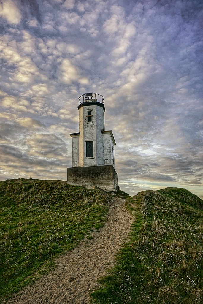
Cattle Point Light is a lighthouse on southern tip of San Juan Island in an area known as Cattle Point, in the Haro Straits of Washington. The first navigational aid on Cattle Point was a lens lantern established in 1888. George Jakle, a soldier who had been stationed at American Camp and had remained on the island raising sheep, was paid to maintain the light. Jakle would tend the light each day and fill the lantern's reservoir each week, using kerosene from five-gallon barrels that were offloaded at nearby Griffin Bay every couple of months by a lighthouse tender.
A radio compass station was established at Cattle Point by the Navy in 1921, and sailors serving there took over maintenance of the light. Using bearings from that stations at Cattle Point, New Dungeness Spit, and Smith Island, ships sailing through the Strait of San Juan de Fuca could pinpoint their location even in dense fog.
The modern 34-foot (10 m), octagonal, concrete tower on Cattle Point was erected in 1935. The lighthouse is located adjacent to the Cattle Point Natural Resources Conservation Area, which is managed by the State Department of Natural Resources, so a Discovery Pass is required for your vehicle. Parking is available near a picnic shelter housed in an old powerhouse, leftover from the Naval Radio Compass Station. Trails lead from the conservation area's shelter to the lighthouse.
One of the most photographed areas of Mount Rainier is of its south face from Reflection Lakes. Anytime you can combine a mountain and wide spanning mountain lake you are bound to make a stunning landscape image. That is of course if the weather and clouds cooperate with the photographer. Thousands of snap shooters, smart phone photographers and amateur to pro photographers make the drive around the south side of Mount Rainier and stop at Reflection Lakes.
During summer the lake shore and hills sides are covered in colorful blooms of wildflowers. Reflection Lakes is closed to swimming and Fishing but nearby Louise Lake is open to fishing and wading.
For a successful image plan on shooting at sunrise and sunset during the summer and fall months.
Mount Rainier is so large and tall that is has its own weather pattern. Which can make taking a photograph tricky. Fast moving high winds can blow in clouds and also clear the south face in just a few minutes. Most photographers make multiple trips up and down the national park. If you have the time to spend a few hours in the park take a notepad with you and write notes about places, mile markers, and description of the trail, area for your Scouting Tips.
Mount Rainier National Park is so vast that you could spend years hiking the trails and revisiting spots during various times of the year and see Mount Rainier in different light every time.
We love to bring you guys the updates to best and greatest photography locations in and around Seattle and the greater Puget Sound area, photography tips and gear related stuff. However, we can’t keep doing that unless we have your continued support. If you would like to purchase any of images featured in an article, please do so by clicking HERE or on the Post Cards and Prints tab above in the header. You can also make secure donation to the travel fund via PayPal. If you frequently shop on Amazon.com, by clicking on the Amazon links listed below you can continue to browse Amazon and any purchase you make will give us a small portion of the sale to continue to run this website.
Banner Links for PEP
Gear Used:
Washington State travel, Washington State travel, Washington Destinations, Photography, Photography spots, best things to do in Seattle, Best things to in Washington State, Washington Tourism Alliance, Washington State Tourism board, recommendations, recommendations for things to see in washington state, things to do in washington state, things to do in seattle, things to do in Tacoma washington, Washington Photographers, Washington nikon shooters, best seattle photography, washington exploration, experience washington, what to do while visiting seattle, seattle top attractions, seattle food, Space Needle, Explore Washington State, Puget Exposure Photography, Puget Exposure, Road Trips through Washington State, Weird Washington, King County, Snohomish County, Seattle, Everett, Tacoma, Kent, Redmond, Kirkland, Washington Sunrises where and when, Washington State Weather,
This historic 1 mile long portion of 196th Ave NE just east of Redmond, WA still has the original 1913 hand laid red brick pavers that were once part of the Yellowstone Trail that connected Seattle to Yellowstone and continued on to Boston, Massachusetts on the east coast.
Built during the horse drawn carriage era and the beginnings of the automobile revolution the brick roadway is one of the few sections along this interstate roadway in original condition. This portion of 196th Ave NE runs between some famous horse farms and sheep farms and various private estates. Towards the north it opens up to a marshland area where hawks, falcons and bald eagles can be scene if you know what time of day and year to look for them.
The posted speed limit is 25mph and for its time a brick road did offer a speedy alternative to deep rutted and muddy dirt roads. Even with today's modern automobile capable of much faster speeds the bumpy road will test your car seat cushioning and shock absorbers as you rumble across the road way.
Gear Used:
Washington State travel, Washington State travel, Washington Destinations, Photography, Photography spots, best things to do in Seattle, Best things to in Washington State, Washington Tourism Alliance, Washington State Tourism board, recommendations, recommendations for things to see in washington state, things to do in washington state, things to do in seattle, things to do in Tacoma washington, Washington Photographers, Washington nikon shooters, best seattle photography, washington exploration, experience washington, what to do while visiting seattle, seattle top attractions, seattle food, Space Needle, Explore Washington State, Puget Exposure Photography, Puget Exposure, Road Trips through Washington State, Weird Washington, King County, Snohomish County, Seattle, Everett, Tacoma, Kent, Redmond, Kirkland, Washington Sunrises where and when, Washington State Weather, Redmond Washington, Yellowstone Road,Yellowstone Trail, Seattle to Boston highway, Redbrick Road Redmond Washington, Historic Roads in Washington, Historic Road in Redmond
Artist Point is located at the very end of Mount Baker Highway, State Route 542 and boasts 360-degree views of Mount Shuksan and Mount Baker, as well as access to a variety of trails. In late summer the open meadows at Artist Point fill with blooming wild flowers backed by the towering rock summit of Mount Shuksan and glacier-crowned Mount Baker.
The road to Artist Point from Heather Meadows is 2.7 miles long (milepost 54.55 to 57.26) and more than 5,000 feet above sea level, is typically buried under snow and closed from October through June.
Artist Point typically opens in July and remains open until the first substantial snowfall of the year, which usually comes in late September or early October.
Please Support Puget Exposure
We love to bring you guys the updates to best and greatest photography locations in and around Seattle and the greater Puget Sound area, photography tips and gear related stuff. However, we can’t keep doing that unless we have your continued support. If you would like to purchase any of images featured in an article, please do so by clicking HERE or on the Post Cards and Prints tab above in the header. You can also make secure donation to the travel fund via PayPal. If you frequently shop on Amazon.com, by clicking on the Amazon links listed below you can continue to browse Amazon and any purchase you make will give us a small portion of the sale to continue to run this website.
Banner Links for PEP
Gear Used:
Washington State travel, Washington State travel, Washington Destinations, Photography, Photography spots, best things to do in Seattle, Best things to in Washington State, Washington Tourism Alliance, Washington State Tourism board, recommendations, recommendations for things to see in washington state, things to do in washington state, things to do in seattle, things to do in Tacoma washington, Washington Photographers, Washington nikon shooters, best seattle photography, washington exploration, experience washington, what to do while visiting seattle, seattle top attractions, seattle food, Space Needle, Explore Washington State, Puget Exposure Photography, Puget Exposure, Road Trips through Washington State, Weird Washington, King County, Snohomish County, Seattle, Everett, Tacoma, Kent, Redmond, Kirkland, Washington Sunrises where and when, Washington State Weather, Artist Point, North Cascades National Forest, SR542, Mount Naker Highway
Roche Harbor is a sheltered harbor on the northwest side of San Juan Island in San Juan County, Washington, United States, and the site of a resort of the same name. Roche Harbor sits along Haro Strait and Canada – United States border. History The story of Roche Harbor began more than 200 years ago, in 1787, when Captain de Haro and his crew became the first Europeans to actually sail among the forested San Juan Islands.
In 1886, John McMillin transformed a sleepy Hudson Bay camp into a full-fledged lime works and company town with a population bigger than Friday Harbor (800+ residents).
Seven decades later, the Tarte Family restored buildings to function and cleared the way for Roche Harbor’s metamorphosis into a boatel and resort.
Since then, the resort has returned to its community-centered roots with the reestablishment of neighborhoods and a village center.






 Washington State travel, Washington State travel, Washington Destinations, Photography, Photography spots, best things to do in Seattle, Best things to in Washington State, Washington Tourism Alliance, Washington State Tourism board, recommendations, recommendations for things to see in washington state, things to do in washington state, things to do in seattle, things to do in Tacoma washington, Washington Photographers, Washington nikon shooters, best seattle photography, washington exploration, experience washington, what to do while visiting seattle, seattle top attractions, seattle food, Space Needle, Explore Washington State, Puget Exposure Photography, Puget Exposure, Road Trips through Washington State, Weird Washington, King County, Snohomish County, Seattle, Everett, Tacoma, Kent, Redmond, Kirkland, Washington Sunrises where and when, Washington State Weather,


