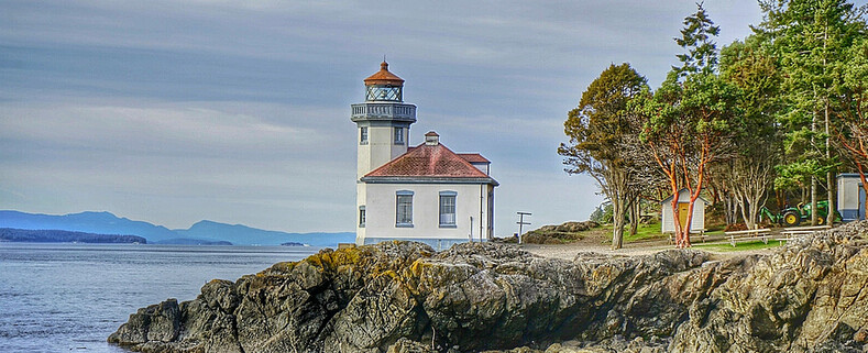
Lime Kiln Lighthouse

Lime Kiln Lighthouse on the west side of San Juan Island, Washington

Lime Kiln Lighthouse on the west side of San Juan Island, Washington

Lime Kiln Lighthouse on the west side of San Juan Island, Washington

Lime Kiln Lighthouse on the west side of San Juan Island, Washington

Lime Kiln Lighthouse on the west side of San Juan Island, Washington

Showing posts with label deception pass. Show all posts

Tuesday, February 5, 2013

No. 165 Bowman Bay, Whidbey Island

Bowman Bay
MAP IT


Bowman Bay is located just north of the Deception Pass Bridge off of Highway on Fidalgo Island. The bay is separated from Lottie Bay to the south by a small and growing sand bar but it still is subject to tidal changes. Check current tidal conditions before your arrival to predict access to the shoreline.
Until the late 1800s, this calm-watered cove was the site of a large Samish village, one of several that existed near Deception Pass.  Evidence of their presence in the area remains in the form of thick groves of Nootka rose that grow atop iron-rich shell middens.
Before receiving its modern name, Bowman Bay was known as “Reservation Bay” due to the period in which it was a military reservation.  In the early 1900s, Bowman Bay was one of several modern-day park areas set aside for military use.  The area was eventually renamed in honor of Amos Bowman, who was one of the first white settlers on Fidalgo Island.  Nearby Anacortes is amalgamation of “Anna Curtis,” Bowman’s wife.  At the turn of the century, Bowman had a wooden dock built at the bay in hopes that it would become a major port, but Bowman’s dream was never realized.


Bowman Pier, Deception Pass
Looking out towards the Puget Sound from Bowman Pier
Bowman Sound Low Tide
Low Tide at Bowman Bay
Bowman Sound Low Tide 2
Another low angle view of Bowman Pier
Gear Used:
 
lens rental Learn Photography Online with the Pros Save $10 Now #KTCJQ12  Receive a FREE GIFT from Think Tank Photo
Washington State travel, Washington State travel, Washington Destinations, Photography, Photography spost, best things to do in Seattle, Best things to in Washington State, Washington Tourism Alliance, Washington State Tourism boared, recommendations, recommendations for things to see in washington state, things to do in washington state, things to do in seattle, things to do in Tacoma washington, Washington Photographers, Washington nikon shooters, best seattle photography, washington exploration, experience washington, what to do while visiting seattle, seattle top attractions, seattle food

Monday, January 28, 2013

No. 161 West Beach, Deception Pass State Park

West Beach

 Deception Pass State Park,
 41020 State Route 20,
Oak Harbor, Washington 98277

MAP IT 


On weekends and on warm summer days the second most popular attraction with in Deception Pass Park aside from the Bridge is West Beach. West Beach is a long, gravelly shoreline dotted with boulders and driftwood and as excellent views of the Olympic Mountains, the San Juan Islands, and even Victoria on a clear day.  Keeping an eye on the changes in tide levels is important if you want to take a stroll around the large boulders to the north and look back at the cut and Deception Pass Bridge.
You can see a variety of wildlife from Killer Whales,  Sea Otters to Bald Eagles, Herons and Hawks playing in the waters and tree line around West Beach.
From the West Beach parking lot you can access the 3000ft long Pacific Northwest Sand Dune Interpretive Trail which runs between the freshwater Cranberry Lake and the Pacific Ocean.
The Sand Dune Interpretive Trail at the south end of West Beach features a variety of habitats ranging from dunes to marsh land.
West Beach has restrooms located in the upper parking lot area and a seasonal concession stand near the start of the Sand Dune trail offering cool drinks and snacks during the summer months.


Deception Pass Cut Having a Picknick on the beach looking out towards Juan De Fuca


Photo Credit: West Beach Sunset by  Jim Lundgren


Deception Pass State Park is located 10 miles and 20 minutes from downtown Anacortes along Hwy 20 towards Oak Harbor.  A 4,134-acre marine and camping park with 77,000 feet of saltwater shoreline, Deception Pass State Park offers 33,900 feet of freshwater shoreline on three lakes and 35 miles of trails, this park has national park size and quality.
Known for breath-taking views, old growth forests and abundant wildlife, its topography features rugged cliffs that drop to meet the swirling waters of Deception Pass.
The main feature of the park is the 180 foot tall Deception Pass Bridge, which was completed in 1935. The quarter mile long bridge spans two cuts in between Fidalgo and Whidbey Island. When the bridge first opened in 1935 on average 700 cars crossed between Whidbey Island and the Mainland. Today over 20,000 cars and trucks cross the bridge daily.
There are vehicle parking lots both north and south of the bridge. The parking lot on the south end of the bridge is accessible from North & South Bound HWY 20 , but the north lot is only accessible from northbound HWY 20.
There is a 3 foot wide pedestrian walkway that you can walk out on to get a birds eye view of the waters below. On either side there are paths to get a lower view off the bridge, but the terrain is unstable so solid footing and safety is a first priority. The tidal surges passing through deception pass can exceed 10 knots.


All images are copyrighted by © Pugetexposure Photography. Do NOT use my images on blogs, personal or professional websites, or any other digital media without my explicit permission.

Gear Used:
 
lens rental Learn Photography Online with the Pros Save $10 Now #KTCJQ12  Receive a FREE GIFT from Think Tank Photo Washington State travel, Washington State travel, Washington Destinations, Photography, Photography spost, best things to do in Seattle, Best things to in Washington State, Washington Tourism Alliance, Washington State Tourism boared, recommendations, recommendations for things to see in washington state, things to do in washington state, things to do in seattle, things to do in Tacoma washington, Washington Photographers, Washington nikon shooters, best seattle photography, washington exploration, experience washington, what to do while visiting seattle, seattle top attractions, seattle food, Fidalgo Island, Where is Deception Pass, Where is Deception Pass Bride, Photos of Deception Pass Bridge, explore deception pass bridge, anacrotes washington, Travel photography in Washington state, amazing landscape photography

Friday, August 10, 2012

No. 90 Deception Pass

Deception Pass 

Deception Pass State Park is located 10 miles and 20 minutes from downtown Anacortes along Hwy 20 towards Oak Harbor.  A 4,134-acre marine and camping park with 77,000 feet of saltwater shoreline, Deception Pass State Park offers 33,900 feet of freshwater shoreline on three lakes and 35 miles of trails, this park has national park size and quality.
Known for breath-taking views, old growth forests and abundant wildlife, its topography features rugged cliffs that drop to meet the swirling waters of Deception Pass.
The main feature of the park is the 180 foot tall Deception Pass Bridge, which was completed in 1935. The quarter mile long bridge spans two cuts in between Fidalgo and Whidbey Island. When the bridge first opened in 1935 on average 700 cars crossed between Whidbey Island and the Mainland. Today over 20,000 cars and trucks cross the bridge daily.
There are vehicle parking lots both north and south of the bridge. The parking lot on the south end of the bridge is accessible from North & South Bound HWY 20 , but the north lot is only accessible from northbound HWY 20.
There is a 3 foot wide pedestrian walkway that you can walk out on to get a birds eye view of the waters below. On either side there are paths to get a lower view off the bridge, but the terrain is unstable so solid footing and safety is a first priority. The tidal surges passing through deception pass can exceed 10 knots.


Deception Pass looking South West
Deception Pass Bridge looking south
Under the Deception Pass Bridge
A Look Underneath the South End Tresses of Deception Pass Bridge


Deception Pass State Park

(Discovery Pass Required !!)

Deception Pass State Park features of 35 miles of hiking trails that meander and climb through ancient tress, rocky shorelines and along miles of shoreline. Depending on the current tide levels you can walk out around the bluff in western corner and walk back towards the Deception Pass Bridge.


Looking east towards deception pass
Looking east Back at Deception Pass Bridge
Deception Pass Bridge
Deception Pass State Park
Experience Washington State by car, History of Deception Pass Whidbey Island in Pictures, Road trip to Deception Pass, What is there to see besides Seattle?, Washington State Photographer, Washington State Landscapes, Washington State Bridges, Deception Pass State Park, Exploring Washington State, Exploring Deception Pass, Whidbey Island, Photos of Deception Pass, Road Trips through Washington, North of Seattle, Beautiful Washington, Amazing Washington, Amazing Images of Washington State

 
Eagle Standing Tall
American Bald Eagle sitting out a snow storm underneath the Deception Pass Bridge


Please note: U.S. Navy jets from nearby Naval Air Station Whidbey Island may fly over the campground at any time for several hours. Navy personnel conduct training missions which are not announced ahead of time. Depending on the direction of the wind, their flight pattern may put them above the park, creating noisy conditions for campers. State Parks cannot be responsible for this significant intrusion into your camping experience.