Lime Kiln Lighthouse

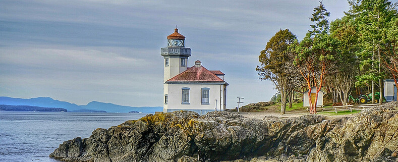
Lime Kiln Lighthouse on the west side of San Juan Island, Washington

Lime Kiln Lighthouse on the west side of San Juan Island, Washington

Lime Kiln Lighthouse on the west side of San Juan Island, Washington

Lime Kiln Lighthouse on the west side of San Juan Island, Washington

Lime Kiln Lighthouse on the west side of San Juan Island, Washington

Showing posts with label waterfalls. Show all posts

Thursday, April 17, 2014

No. 265 Springtime is a great time to visit Washington State Water Falls

As we enter the 5 week of Spring of 2014 the flowers are in bloom everywhere it seems and the weather is producing more blue skies and warmer temps consistently. Which puts most people in a happier mood.
Temperatures in the lowlands are staying above 40 degrees and the temperatures in the mountains are getting warmer as well. This means the snow and ice that fell and accumulated since last October is beginning to thaw and looking for a way to the ocean. 
Now is the best time to go out and see waterfalls running at full levels. The April Spring Showers combined with ice and snow melt add dramatic volumes of water rushing down the sides of mountains and cascading over the edges of waterfalls. 
Though some trails still may have residual snow and may be muddy they are worth the hike. During the summer months when forest floors and trails are dry there is upwards of 60% less water moving down the mountain causing larger falls to run at low levels and many smaller waterfalls disappear as their water sources dry up. 


Here is a list of waterfalls inside Washington State Parks that are worth a hike:


Palouse Region Palouse Falls - Eastern Washington
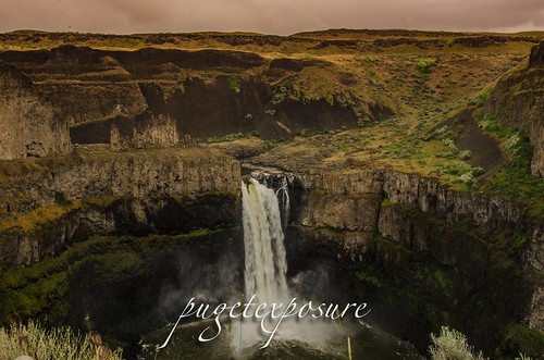
The Palouse Falls is tucked away in the Eastern part of Washington State. After a very windy drive, including a few miles on dirt roads, you can find this amazing location. The falls consists of an upper falls with a drop of ~20 feet (6.1 m) which lies 1,000 feet (300 m) north northwest of the main drop, and a lower falls, with a drop of ~180 feet (55 m).


Wallace Falls State ParkWallace Falls - Gold Bar, WA
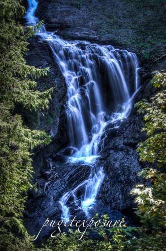
Cascade FallsWallace Falls, named after homesteaders Joe and Sarah Kwayaylsh members of the Skykomish tribe, is a 4,735 acre forest land on the western slope of the North Cascade Mountain range in Snohomish County. The park has three back country lakes, Jay Lake, Shaw Lake and Wallace Lake which are connected via the Wallace River. The river trickles, snakes, gurgles and plunges its way through the park until the valley basin. 


Cascade Falls - Orcas Island, WA
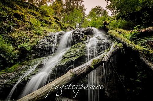
At about 40 feet tall, Cascade Falls is the largest waterfall in the San Juan Islands. Cascade Creek squiggles down a flume, dropping through a jumble of logs and branches before it veils out over a broad bulbous face into a small grotto lined with several old growth cedar trees. 
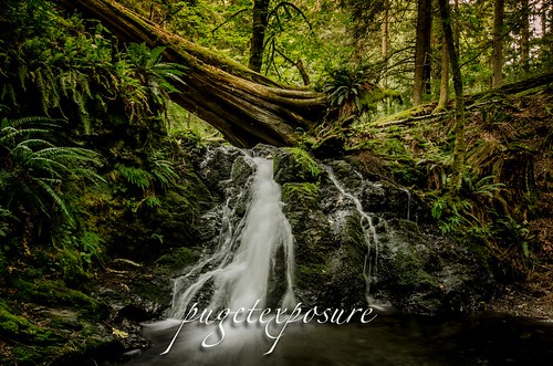


Rustic Falls, Cascade Creek, Moran State Park Rustic Falls - Orcas Island, WA 
Rustic Falls is part of Cascade Creek, which runs between Mountain Lake and Cascade Lake in Moran State Park. The 0.8 mile walk from the trail head is located on the east side of Cascade Lake in Moran State Park Orcas Island

Wednesday, October 23, 2013

No. 224 Christine Falls Mount Rainier National Park

Mount Rainier National Park- South Slope

Christine Falls is a waterfall on Van Trump Creek in Mt Rainier National Park. The falls is a two tiered drop totaling 69 feet (21 m) feet high. The upper drop is 32 feet (9.8 m) high and the lower drop is 37-foot (11 m). The lower drop cascades under the Christine Falls Bridge which was built in 1928. 
Christine Falls are located immediately next to SR 706, on Van Trump Creek, about 2 1/2 miles east of Cougar Rock campground, or about 3 1/2 miles west of Narada Falls. It's pretty obvious, due to the amount of people usually around the falls, the tight gorge next to the bridge and the sign on the far side of the bridge. A short path leads to good views upstream to the falls from a fenced overlook.


Mount Rainier National Park

Mount Rainier National Park


Please Support Puget Exposure 

 We love to bring you guys the updates to best and greatest photography locations in and around Seattle and the greater Puget Sound area, photography tips and gear related stuff. However, we can’t keep doing that unless we have your continued support. If you would like to purchase any of images featured in an article, please do so by clicking HERE or on the Post Cards and Prints tab above in the header. You can also make secure donation to the travel fund via PayPal. If you frequently shop on Amazon.com, by clicking on the Amazon links listed below you can continue to browse Amazon and any purchase you make will give us a small portion of the sale to continue to run this website. Banner Links for PEP Gear Used:
 
lens rental Washington State travel, Washington State travel, Washington Destinations, Photography, Photography spots, best things to do in Seattle, Best things to in Washington State, Washington Tourism Alliance, Washington State Tourism board, recommendations, recommendations for things to see in washington state, things to do in washington state, things to do in seattle, things to do in Tacoma washington, Washington Photographers, Washington nikon shooters, best seattle photography, washington exploration, experience washington, what to do while visiting seattle, seattle top attractions, seattle food, Space Needle, Explore Washington State, Puget Exposure Photography, Puget Exposure, Road Trips through Washington State, Weird Washington, King County, Snohomish County, Seattle, Everett, Tacoma, Kent, Redmond, Kirkland, Washington Sunrises where and when, Washington State Weather, Christine Falls, Mount Rainier National Park, Waterfalls

Wednesday, September 25, 2013

No. 223 Gold Bar's Hidden Gem Wallace Falls State Park

Wallace Falls State Park
Gold Bar, WA
MAP IT


Driving Directions:

From Everett follow US 2 for 28 miles east to the hamlet of Gold Bar. Just before milepost 28, turn left onto 1st Street (signed for Wallace Falls State Park). Pro-ceed for 0.4 mile to a four-way stop. Turn right onto May Creek Road and continue for 1.5 miles to Wallace Falls State Park and the trailhead (elev. 300 ft). Restrooms and water available at parking lot.
Wallace Falls, named after homesteaders Joe and Sarah Kwayaylsh members of the Skykomish tribe, is a 4,735 acre forest land on the western slope of the North Cascade Mountain range in Snohomish County. The park has three back country lakes, Jay Lake, Shaw Lake and Wallace Lake which are connected via the Wallace River. The river trickles, snakes, gurgles and plunges its way through the park until the valley basin. 
Some where within the park there has to be a waterfall worth of a title right?
Well there are more than 9 waterfalls in the park. Some small some larger, some are running year round while others only run in late winter/early spring with the snowmelt run off. 
The 4 falls that are more easily accessible can be found along the Woody Trail, a 2.3 mile / 3.7 km long dirt trail that is well maintained and well marked. After recent rain fall, the trail might be come very muddy and slippery in spots. There are numerous switch backs and steep inclines that have tall raised steps. At 6'1 I did not have much trouble navigating the steps and switch backs, but those shorter might have more difficulty with the high steps. 
2.3 miles may not seem like much, just remember its 2.3 miles each way (5.6 miles round trip) and its up and down hill sides with incremental elevation gains of 500 feet in short distances. Proper footwear and good to better conditioning is required to make it a safe and enjoyable hike. We made Wallace Falls into a mid morning hike and returned to the trailhead in about 3 1/2 hours with stops along the way (see pictures below :) 
Image created with Snapseed
Wallace River


Wallace Falls State Park
Crossing over Small Falls 
Image created with Snapseed
The Trail begins with a 1/4 walk under some buzzing high energy power lines
                                                                     

Image created with Snapseed

Image created with Snapseed
Another bend in the trail that follows Wallace River 
S
Image created with Snapseed
Along the trail there are a few benches to take a break and enjoy the sights and sounds
Sma
Wallace Falls State Park


Wallace Falls State Park
This is one of many wooden bridges to cross along the trail 

Wallace Falls State Park
Crossing over the North Fork of Wallace River

Wallace Falls State Park


Wallace Falls State Park


Wallace Falls State Park
Middle Falls Overlook


Wallace Falls State Park
Middle Falls Overlook


Wallace Falls State Park
Wallace Falls State Park is DOg Friendly, so bring you dog on a leash for some exploring


  Please Support Puget Exposure 

 We love to bring you guys the updates to best and greatest photography locations in and around Seattle and the greater Puget Sound area, photography tips and gear related stuff. However, we can’t keep doing that unless we have your continued support. If you would like to purchase any of images featured in an article, please do so by clicking HERE or on the Post Cards and Prints tab above in the header. You can also make secure donation to the travel fund via PayPal. If you frequently shop on Amazon.com, by clicking on the Amazon links listed below you can continue to browse Amazon and any purchase you make will give us a small portion of the sale to continue to run this website. Banner Links for PEP Gear Used:
 
lens rental Washington State travel, Washington State travel, Washington Destinations, Photography, Photography spots, best things to do in Seattle, Best things to in Washington State, Washington Tourism Alliance, Washington State Tourism board, recommendations, recommendations for things to see in washington state, things to do in washington state, things to do in seattle, things to do in Tacoma washington, Washington Photographers, Washington nikon shooters, best seattle photography, washington exploration, experience washington, what to do while visiting seattle, seattle top attractions, seattle food, Space Needle, Explore Washington State, Puget Exposure Photography, Puget Exposure, Road Trips through Washington State, Weird Washington, King County, Snohomish County, Seattle, Everett, Tacoma, Kent, Redmond, Kirkland, Washington Sunrises where and when, Washington State Weather, Wallace Falls State Park, Washington State Park, Lower Falls, Upper Falls, Middle Falls, Snohomish County

Monday, September 16, 2013

No. 220 Rainbow Falls State Park

Rainbow Falls State Park
4008 State Highway 6
Chehalis, WA 98532

From I-5: Take exit 77, go west on state highway 6 about 17 miles. Turn right on Chandler road (will cross over a new bridge) go 0.3 miles and turn right on Leudinghaus road. Travel 0.8 miles on Leudinghaus road and turn right into the park. Upon entering the park, the campground area will be to your right and the group camp and day-use area will be to your left.

Rainbow Falls State Park is located along the east flow of the Chehalis River around 16 miles west of the city of Chehalis.  The 139 acre state park is split in two by the Chehalis River and State highway 6. A heavy winter storm in December of 2007 washed out a vehicle bridge that was the former park entrance. The new entrance to the park is on the north side of the river along Leudinghaus Road. 
To view Rainbow Falls head south from the rangers station about 200 yards and look down past the old bridge foundation. The "Falls" is more like rapid than an actual waterfall. Depending on river height you may or may not see it. The Chehalis River makes an easterly turn through Rainbow Falls before heading northwest and ending in Aberdeen, WA.
The drop or rapid is around 10 feet over a layer of basalt rock left over from volcanic activity in the area thousands of years ago.


Rainbow Falls State Park Rainbow Falls State Park Rainbow Falls State Park

Events
Free days at state parks: Visit Washington state parks for free. The Discover Pass is not required to visit a state park on ten designated free days in 2013.

The 2013 State Parks free days are as follows:

Jan. 21 – In honor of Martin Luther King Day
March 30 – In honor of Washington State Parks' 100th birthday on March 19
April 27 and 28 – National Parks Week
June 1 – National Trails Day
June 8 and 9 – National Get Outdoors Day and Department of Fish and Wildlife Free Fishing weekend
Aug. 4 – Peak season free day
Sept. 28 – National Public Lands Day
Nov. 9 through 11 – Veteran's Day weekend

Please note: A Discover Pass is still required to access lands managed by the Washington State Department of Natural Resources and the Washington Department of Fish and Wildlife during State Parks free days. For more information, please visitwww.discoverpass.wa.gov.

Full list of events at Washington State Parks


Please Support Puget Exposure 

 We love to bring you guys the updates to best and greatest photography locations in and around Seattle and the greater Puget Sound area, photography tips and gear related stuff. However, we can’t keep doing that unless we have your continued support. If you would like to purchase any of images featured in an article, please do so by clicking HERE or on the Post Cards and Prints tab above in the header. You can also make secure donation to the travel fund via PayPal. If you frequently shop on Amazon.com, by clicking on the Amazon links listed below you can continue to browse Amazon and any purchase you make will give us a small portion of the sale to continue to run this website. Banner Links for PEP Gear Used:
 
lens rental Washington State travel, Washington State travel, Washington Destinations, Photography, Photography spots, best things to do in Seattle, Best things to in Washington State, Washington Tourism Alliance, Washington State Tourism board, recommendations, recommendations for things to see in washington state, things to do in washington state, things to do in seattle, things to do in Tacoma washington, Washington Photographers, Washington nikon shooters, best seattle photography, washington exploration, experience washington, what to do while visiting seattle, seattle top attractions, seattle food, Space Needle, Explore Washington State, Puget Exposure Photography, Puget Exposure, Road Trips through Washington State, Weird Washington, King County, Snohomish County, Seattle, Everett, Tacoma, Kent, Redmond, Kirkland, Washington Sunrises where and when, Washington State Weather, Rainbow Falls State Park, Washington STate Parks, waterfalls in washington

Wednesday, August 22, 2012

No.97 Sul Duc Falls

Sul Duc Falls
Olympic National Park

GETTING THERE: From Port Angeles, drive west 27 miles on U.S. Highway 101, turn south on Sol Duc Hot Springs Road (also known as the Sol Duc River Road). The Sol Duc Ranger Station is about 12 miles from U.S. 101. Sol Duc Campground is an Olympic National Park campground, not to be confused with an RV campground operated by the resort. The end of the road is just under 14 miles, elevation 2,000 feet.
Normally most waterfalls are approached from a creek or river bed level, but here a Sul Duc Falls you are above the waterfall which offers a unique not available at most falls.  


Sul Duc Falls

A 0.8 mile walk along a wide, well trekked trail, winds you under the canopys of old-growth forest trees, numerous tiny creeks dot the trail on your way to the Canyon Creek shelter, built by the Civilian Conservation Corps. The shelter is well worth a visit. A one-of-a-kind structure with a cupola, it's a good place to leave your pack on a wet day while you hike a bit farther to view the falls. As you approach the Canyon Creek shelter you will start to hear the rumblings of thousands of gallons of water from the Sul Duc River cascading over a sandstone brim in three separate falls, then flows furiously through a deep canyon. A rustic wooden bridge spans the chasm 70 feet above the canoyon and you will have to shout to be heard above the roar. Cross the bridge and turn left to head up river for alternate views of the bridge and falls. Hikers can continue on the Sol Duc Trail or explore the Canyon Creek Trail. It is just over three miles to upper Deer Lake at 3,500 feet and a junction with the Bogachiel River Trail.

In summer, the spray will dampen your face and camera lenses. The falls don't get much sun, but when shafts of sunlight beam between the somber trees, it is a cosmic moment.
With or without sun, there is a wild beauty that no season of the year can subdue. Pick a season -- you can't miss. Just make sure the Sol Duc River Road -- also known as Sol Duc Hot Springs Road -- is open before you set out, as storms can cause temporary closures.
Bring a tripod, wide angle lens, shutter release and plenty of lens clothes to dry off the water spray. 

The Sol Duc Trail has two trailheads, but the shortest approach to Sol Duc Falls is from the end of the Sol Duc River Road, elevation 2,000 feet. The other approach is from the Sol Duc Campground (1,700 feet). The trail is wide and easy to hike through old-growth forest of Douglas fir. The trail joins the Canyon Creek Trail and Sol Duc Falls at .7 miles. The Sol Duc Trail continues climbing to intersect the Appleton Pass trail at five miles (3,100 feet) and eventually reaches the High Divide at 8 1/2 miles, elevation 5,050 feet.


Sul Duc Falls
Click here to order Greeting Cards ad large wall prints of Sul Duc Falls
lens rental Learn Photography Online with the Pros Save $10 Now #KTCJQ12  Receive a FREE GIFT from Think Tank Photo san juan islands photos

Wednesday, August 8, 2012

No. 89 Visiting Orcas Island

Orcas Island is the largest island of the San Juan Island Chain in the Puget Sound waters between the United States and Canada.
With a land area of 57.3 square miles and a population of 4,453, Orcas Island is slightly larger, but less populous, than neighboring San Juan Island. Orcas is shaped like a pair of saddlebags, separated by fjord-like Eastsound, with Massacre Bay on the south side, and tiny Skull Island just off the coast. At the northern end of the island is the village of Eastsound, the largest population center on Orcas and the second largest in San Juan County.
Other, smaller towns - or hamlets - on the island include Orcas (where the inter-island/mainland ferry lands), West Sound (technically part of Eastsound), Deer Harbor, Rosario (technically part of Eastsound), Olga and Doe Bay.
Orcas Island is accessible by air via Eastsound Airport or water landings by seaplane as well as by water via the Washington State Ferry system or private watercraft. During the summer season, there is an island shuttle that runs from the ferry landing to Eastsound and other points.

Arrive early or stay late in Anacortes, here are somethings to do in Anacortes

Orcas

The Washington Ferry Terminal is on the south end of Orcas Island. There are a few hotels, gift shops and restaurants within walking distance that you can check out on arrival after the 90min ferry sailing from Anacortes or after stagging in the ferry departure lanes on your departure. Ferry wait times can range from 1 to 3 hours on busy weekend afternoons.

Bow Riders - Passengers face the salt spray on board @wsdot ferry. San Juan's, WaOrcas Island Ferry


Deer Harbor

Deer Harbor located 25min west of Orcas on the southwest corner of Orcas Islands is main hub for water activities such as kayaking, fishing and whale watching excursions. The town wraps around a small cove and rise up on the hill. Unless you plan on booking an activity, arriving on a personal boat  or staying in a resort the limited public parking and lack of shops or waterfront access won't hold your visit for more than 20min of looking at large private yachts parked in the marina.
Deer Flowers Snack Bar, Deer Harbor- Orcas Island, Wa

Eastsound

At the center of the island, at the top of a beautiful fjord, Eastsound is a walker’s village. It definitely has that small town feel with its narrow roads, one way streets and limited street parking. There are  art galleries, boutiques, restaurants, cafes, and grocery stores within walking distance of the shoreline. However with only 5 parking spots your best bet is to park in the Island Market's parking lot and go explore on foot.
Orcas Island is an ISLAND with locals on ISLAND TIME. Do your best to pack everything you need for your trip especially photo equipment. If you live in a metropolitan area you might need to understand that ISLAND TIME works a bit differently. Shops open late in the morning and close early. Some are closed Sunday and Monday others Tuesday Wednesday. And since getting inventory to an island 90min away on a ferry, the store items are limited.
If you have a special diet, taking meds make sure to bring extra along for your visit.
My favorite spots in Eastsound are the Emmanuel Episcopal Parish with its Labyrinth and the Off-Leash Dog Park.
Beach access on the west and north sides of Orcas Island are mostly  located on Forestry Lands or owned by private people. There is limited beach access to north limited to just under 50 yards between two houses. If you use google maps or a gps unit to find roads and green areas you might find out that they are part of private resort clubs or private do not trespass roads.
If you need to stretch out your legs and arms from the travel getting to Orcas Island, park your car in Eastsound and spend an hour walking through town, then head east to Moran State Park for its lakes, trails and 2400ft high Mount Constitution scenic overlook.


Walking the Line - Emmanuel Parish, Eastsound, Orcas Island
Art Cottage Eastsound, Orcas Island WashingtonOrcas Island Off-Leash Dog Park


Moran State Park

Moran State Park is a 5,252-acre camping park with five freshwater lakes and over 30 miles of hiking trails, scenic overlooks, waterfalls and wildlife spotting opportunities. Atop the 2,409-foot-high Mt. Constitution, the highest point on the San Juan Islands, there stands a stone observation tower built by the Civilian Conservation Corps in 1936. The tower offers panoramic views of the surrounding islands, the Cascade Mountains and a variety of Canadian and American cities.

Cascade Waterfall
Rustic Falls
San Juan Artwork Gallery


Mount Constitution Sunset Orcas IslandCascade FallsCascade Lakemount constitution sunset, orcas island lens rental Learn Photography Online with the Pros Save $10 Now #KTCJQ12  Receive a FREE GIFT from Think Tank Photo

No. 88 Cascade Falls, Moran State Park

Where is Cascade Falls?
Cascade Falls is the second waterfall after Rustic Falls along the Cascade Creek, which runs between Mountain Lake and Cascade Lake in Moran State Park. Walk 0.9 miles from the trail head which is located on the east side of Cascade Lake in Moran State Park Orcas Island. From the small town of Eastsound head southeast on Olga Road and it will lead you right into the middle of the Park. After passing Cascade Lake keep left at the fork in the road for another 1/2 mile and you will see the parking lot and trail head for Rustic, Cascade, Canyon, Hidden and Rosario Falls.
    At about 40 feet tall, Cascade Falls is the largest waterfall in the San Juan Islands. Cascade Creek squiggles down a flume, dropping through a jumble of logs and branches before it veils out over a broad bulbous face into a small grotto lined with several old growth cedar trees. While I certainly don't think the waterfalls of Orcas Island are worth seeing alone (especially considering the cost of the ferry), should one find themselves on the island, the quick walk through the park is worth undertaking.

Cascade Falls
Click here to order a Print of Cascade Falls
Cascade Falls
Click here to order a Artwork Print

Checkout other Waterfall Images available as greeting cards and larger wall prints 

San Juan Island Artwork Gallery


What can I see and do at Cascade Falls?
The ancient and towering forests keep the Creek and Trail cool and shaded. The giant red cedars and other evergreens that make up the thick canopy are impressive throughout the year. Stroll along the creek side path that connects Mountain Lake to Cascade Lake and enjoy the quiet relaxation afforded by the deep forest.

When is Rustic Falls open?
The Park is open for day use all year long. The campsites and swimming area are open seasonally, as are the park offices. The Falls are at their most active in the winter and spring when the water volume is highest.
How much does Rustic Falls cost?
Moran State Park requires a Discover Pass. You can buy them on a daily basis for $10.00 or for $30.00 you receive an annual Pass. The nearby campgrounds also require an additional fee.
Who can I call if I have more questions?
The Moran State Park Rangers can help you with any questions you might have. (360) 376-2326. lens rental Learn Photography Online with the Pros Save $10 Now #KTCJQ12  Receive a FREE GIFT from Think Tank Photo Washington State travel, Washington State travel, Washington Destinations, Photography, Photography spost, best things to do in Seattle, Best things to in Washington State, Washington Tourism Alliance, Washington State Tourism board, recommendations, recommendations for things to see in washington state, things to do in washington state, things to do in seattle, things to do in Tacoma washington, Washington Photographers, Washington nikon shooters, best seattle photography, washington exploration, experience washington, what to do while visiting seattle, seattle top attractions, visiting the san juan islands, moran state park on orcas island, mount constitution orcas island, washington san juan islands, landscape photography of orcas island, hiking on orcas island, hikingin the san juan, hikingin the san juan islands, aerial view of orcas island, washington state road trips, washington state ferry, washington photography, washington state landscape photographers, washington state waterfalls, san juan island waterfalls, waterfall photography, what to see on orcas island, experience san juan county, travels through washington