


Here's 8 easy to moderate walks/hikes that can balance out the Turkey Day meal and experience the pacific northwest outdoors around Seattle.
Seattle
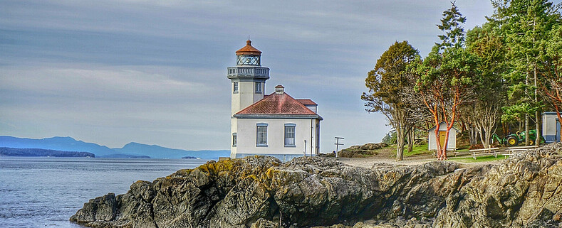
1. Discovery Park - http://pugetexposure.blogspot.com/2011/09/west-point-lighthouse-discovery-park.html
 The site is one of breathtaking majesty. Situated on Magnolia Bluff overlooking Puget Sound, Discovery Park offers spectacular view of both the Cascade and the Olympic Mountain ranges. The secluded site includes two miles of protected tidal beaches as well as open meadow lands, dramatic sea cliffs, forest groves, active sand dunes, thickets and streams.
East of Seattle
Kirkland, Washington
2. Juanita Bay http://pugetexposure.blogspot.com/2012/05/juanita-bay-kirkland-washingotn.html
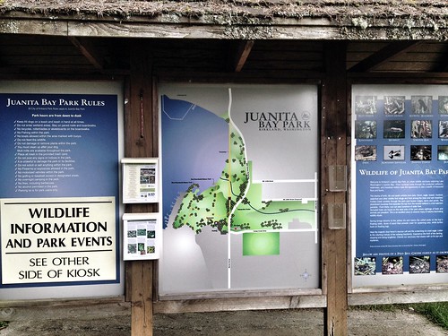 Juanita Bay Park is a 110 acre open area that features paved trails, raised boardwalks, open lawn areas with benches and picnic tables. The park is at the bottom of Kirkland's north hill and surrounds the northeast shoreline of Lake Washington. Just steps away from Kirkland's Marke Street begins this Urban WIldlife Habitat. The seemless mix of tall trees, green space, wetlands, marsh, and lake water provide protection and large selection of food source to sustain a large variety of animal
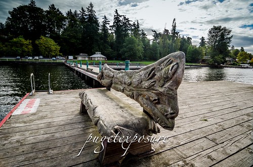 Waverly Park is one of those hidden lake side parks that only locals seem to know about. It is a few blocks off the main road which makes it hard for passers by to easily stumble up on this waterfront park. Located at the bottom of a hill his park offers nearly 500 feet of waterfront on 2.76 acres of prime waterfront real estate right on Lake Washington. Features public dock, picnic tables, benches, restrooms, children’s playground, open lawn areas, on-site parking, enclosed swimming area, fishing area, and windsurfing area. During the summer months a privately run refreshment stand serves up drinks and ice cream to cool off.
Snoqualmie
4. Snoqualmie Falls http://pugetexposure.blogspot.com/2012/05/snoqualmie-falls.html
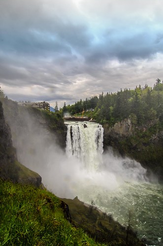 Snoqualmie Falls is a 268 ft (82 m) waterfall on the Snoqualmie River between Snoqualmie and Fall City, Washington,USA. It is one of Washington's most popular scenic attractions, but is perhaps best known internationally for its appearance in the cult television series Twin Peaks. More than 1.5 million visitors come to the Falls every year, where there is a two acre (8,000 m²) park, an observation deck, and a gift shop.
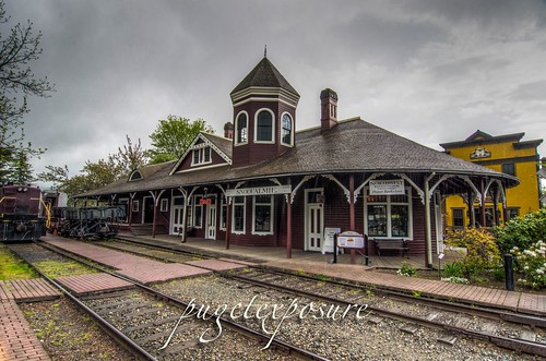 The Snoqualmie Depot was constructed in 1890 by the Seattle, Lake Shore and Eastern Railway. It was used by successor companies Seattle and International Railroad, Northern Pacific Railway, and the Burlington Northern Railroad. The Snoqualmie Depot is open 7 days a week year 'round (closed Thanksgiving, Christmas Day, and New Year's Day; there is limited access during Day Out With Thomas and Santa Train events).
North of Seattle
6. Arlington
Centennial Trail - http://pugetexposure.blogspot.com/2014/01/no-233-nakashima-heritage-barn.html
Started in 1989 during Washington State's 100th centennial celebration, the Centennial Trail is a 30 mile long paved pedestrian walkway. At 12 feet wide, slight grade this trail is popular for walkers, hikers, dogs, cyclists and even riders on horseback with the flanked grassy path running parallel to the trail. The Centennial Trail runs from downtown Snohomish to the north to the Skagit Valley County Line. With future plans to expand and connect it other popular area trails in the north and the south such as Woodinville's Burke-Gilman Trail. Since 2011 Snohomish County has added 9 miles to the Centennial Trail which runs through the towns of Snohomish, Lake Stevens, Marysville and Arlington as a "Rails to Trails" project repurposing a former Burlington-Norther Railroad line.
3. Everett
7. Spencer Island - http://pugetexposure.blogspot.com/2013/01/154.html
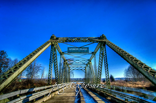 Spencer Island lies in the heart of the Snohomish River Estuary, an ecosystem formed by mixing a freshwater system (the Snohomish River) and a saltwater system (Port Gardner Bay).
It is one of the best places in the Snohomish River Estuary to view waterfowl and shorebirds such as ducks, heron, hawks and bald eagles. If you watch your steps you might see some small and larger mamals such as river otters and deer.
On clear days the snow capped tops of the cascade mountain range and Mount Baker are visible to the east and to the north.
The island is co-owned by Snohomish County and the Washington Department of Fish and Wildlife. Snohomish County owns the south half of the island, while WDFW owns the north half.
Spencer Island lies in the heart of the Snohomish River Estuary, an ecosystem formed by mixing a freshwater system (the Snohomish River) and a saltwater system (Port Gardner Bay).
It is one of the best places in the Snohomish River Estuary to view waterfowl and shorebirds such as ducks, heron, hawks and bald eagles. If you watch your steps you might see some small and larger mamals such as river otters and deer.
On clear days the snow capped tops of the cascade mountain range and Mount Baker are visible to the east and to the north.
The island is co-owned by Snohomish County and the Washington Department of Fish and Wildlife. Snohomish County owns the south half of the island, while WDFW owns the north half.
4. Gold Bar
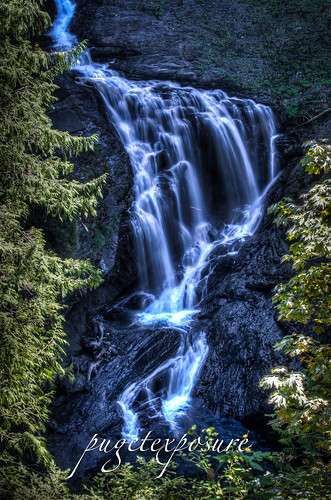 Wallace Falls, named after homesteaders Joe and Sarah Kwayaylsh members of the Skykomish tribe, is a 4,735 acre forest land on the western slope of the North Cascade Mountain range in Snohomish County. The park has three back country lakes, Jay Lake, Shaw Lake and Wallace Lake which are connected via the Wallace River. The river trickles, snakes, gurgles and plunges its way through the park until the valley basin.
Some where within the park there has to be a waterfall worth of a title right?
Well there are more than 9 waterfalls in the park. Some small some larger, some are running year round while others only run in late winter/early spring with the snowmelt run off.
The 4 falls that are more easily accessible can be found along the Woody Trail, a 2.3 mile / 3.7 km long dirt trail that is well maintained and well marked. After recent rain fall, the trail might be come very muddy and slippery in spots. There are numerous switch backs and steep inclines that have tall raised steps. At 6'1 I did not have much trouble navigating the steps and switch backs, but those shorter might have more difficulty with the high steps.
2.3 miles may not seem like much, just remember its 2.3 miles each way (5.6 miles round trip) and its up and down hill sides with incremental elevation gains of 500 feet in short distances. Proper footwear and good to better conditioning is required to make it a safe and enjoyable hike. We made Wallace Falls into a mid morning hike and returned to the trailhead in about 3 1/2 hours with stops along the way
Wallace Falls, named after homesteaders Joe and Sarah Kwayaylsh members of the Skykomish tribe, is a 4,735 acre forest land on the western slope of the North Cascade Mountain range in Snohomish County. The park has three back country lakes, Jay Lake, Shaw Lake and Wallace Lake which are connected via the Wallace River. The river trickles, snakes, gurgles and plunges its way through the park until the valley basin.
Some where within the park there has to be a waterfall worth of a title right?
Well there are more than 9 waterfalls in the park. Some small some larger, some are running year round while others only run in late winter/early spring with the snowmelt run off.
The 4 falls that are more easily accessible can be found along the Woody Trail, a 2.3 mile / 3.7 km long dirt trail that is well maintained and well marked. After recent rain fall, the trail might be come very muddy and slippery in spots. There are numerous switch backs and steep inclines that have tall raised steps. At 6'1 I did not have much trouble navigating the steps and switch backs, but those shorter might have more difficulty with the high steps.
2.3 miles may not seem like much, just remember its 2.3 miles each way (5.6 miles round trip) and its up and down hill sides with incremental elevation gains of 500 feet in short distances. Proper footwear and good to better conditioning is required to make it a safe and enjoyable hike. We made Wallace Falls into a mid morning hike and returned to the trailhead in about 3 1/2 hours with stops along the way
Seattle
1. Discovery Park - http://pugetexposure.blogspot.com/2011/09/west-point-lighthouse-discovery-park.html

East of Seattle
Kirkland, Washington
2. Juanita Bay http://pugetexposure.blogspot.com/2012/05/juanita-bay-kirkland-washingotn.html
Juanita Bay Park is a 110 acre open area that features paved trails, raised boardwalks, open lawn areas with benches and picnic tables. The park is at the bottom of Kirkland's north hill and surrounds the northeast shoreline of Lake Washington. Just steps away from Kirkland's Marke Street begins this Urban WIldlife Habitat. The seemless mix of tall trees, green space, wetlands, marsh, and lake water provide protection and large selection of food source to sustain a large variety of animal3. Waverly Beach Park http://pugetexposure.blogspot.com/2012/10/131.html
Waverly Park is one of those hidden lake side parks that only locals seem to know about. It is a few blocks off the main road which makes it hard for passers by to easily stumble up on this waterfront park. Located at the bottom of a hill his park offers nearly 500 feet of waterfront on 2.76 acres of prime waterfront real estate right on Lake Washington. Features public dock, picnic tables, benches, restrooms, children’s playground, open lawn areas, on-site parking, enclosed swimming area, fishing area, and windsurfing area. During the summer months a privately run refreshment stand serves up drinks and ice cream to cool off. Snoqualmie
4. Snoqualmie Falls http://pugetexposure.blogspot.com/2012/05/snoqualmie-falls.html
Snoqualmie Falls is a 268 ft (82 m) waterfall on the Snoqualmie River between Snoqualmie and Fall City, Washington,USA. It is one of Washington's most popular scenic attractions, but is perhaps best known internationally for its appearance in the cult television series Twin Peaks. More than 1.5 million visitors come to the Falls every year, where there is a two acre (8,000 m²) park, an observation deck, and a gift shop.5. Northwest Railway Museum http://pugetexposure.blogspot.com/2012/07/northwest-railway-musuem.html
The Snoqualmie Depot was constructed in 1890 by the Seattle, Lake Shore and Eastern Railway. It was used by successor companies Seattle and International Railroad, Northern Pacific Railway, and the Burlington Northern Railroad. The Snoqualmie Depot is open 7 days a week year 'round (closed Thanksgiving, Christmas Day, and New Year's Day; there is limited access during Day Out With Thomas and Santa Train events). North of Seattle
6. Arlington
Centennial Trail - http://pugetexposure.blogspot.com/2014/01/no-233-nakashima-heritage-barn.html
Started in 1989 during Washington State's 100th centennial celebration, the Centennial Trail is a 30 mile long paved pedestrian walkway. At 12 feet wide, slight grade this trail is popular for walkers, hikers, dogs, cyclists and even riders on horseback with the flanked grassy path running parallel to the trail. The Centennial Trail runs from downtown Snohomish to the north to the Skagit Valley County Line. With future plans to expand and connect it other popular area trails in the north and the south such as Woodinville's Burke-Gilman Trail. Since 2011 Snohomish County has added 9 miles to the Centennial Trail which runs through the towns of Snohomish, Lake Stevens, Marysville and Arlington as a "Rails to Trails" project repurposing a former Burlington-Norther Railroad line.
3. Everett
7. Spencer Island - http://pugetexposure.blogspot.com/2013/01/154.html
Spencer Island lies in the heart of the Snohomish River Estuary, an ecosystem formed by mixing a freshwater system (the Snohomish River) and a saltwater system (Port Gardner Bay).
It is one of the best places in the Snohomish River Estuary to view waterfowl and shorebirds such as ducks, heron, hawks and bald eagles. If you watch your steps you might see some small and larger mamals such as river otters and deer.
On clear days the snow capped tops of the cascade mountain range and Mount Baker are visible to the east and to the north.
The island is co-owned by Snohomish County and the Washington Department of Fish and Wildlife. Snohomish County owns the south half of the island, while WDFW owns the north half.4. Gold Bar
8. Wallace Falls State Park http://pugetexposure.blogspot.com/2013/09/wallace-falls-state-park-gold-bar-wa.html
Wallace Falls, named after homesteaders Joe and Sarah Kwayaylsh members of the Skykomish tribe, is a 4,735 acre forest land on the western slope of the North Cascade Mountain range in Snohomish County. The park has three back country lakes, Jay Lake, Shaw Lake and Wallace Lake which are connected via the Wallace River. The river trickles, snakes, gurgles and plunges its way through the park until the valley basin.
Some where within the park there has to be a waterfall worth of a title right?
Well there are more than 9 waterfalls in the park. Some small some larger, some are running year round while others only run in late winter/early spring with the snowmelt run off.
The 4 falls that are more easily accessible can be found along the Woody Trail, a 2.3 mile / 3.7 km long dirt trail that is well maintained and well marked. After recent rain fall, the trail might be come very muddy and slippery in spots. There are numerous switch backs and steep inclines that have tall raised steps. At 6'1 I did not have much trouble navigating the steps and switch backs, but those shorter might have more difficulty with the high steps.
2.3 miles may not seem like much, just remember its 2.3 miles each way (5.6 miles round trip) and its up and down hill sides with incremental elevation gains of 500 feet in short distances. Proper footwear and good to better conditioning is required to make it a safe and enjoyable hike. We made Wallace Falls into a mid morning hike and returned to the trailhead in about 3 1/2 hours with stops along the way


