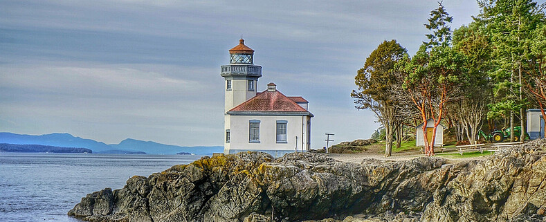
Lime Kiln Lighthouse

Lime Kiln Lighthouse on the west side of San Juan Island, Washington

Lime Kiln Lighthouse on the west side of San Juan Island, Washington

Lime Kiln Lighthouse on the west side of San Juan Island, Washington

Lime Kiln Lighthouse on the west side of San Juan Island, Washington

Lime Kiln Lighthouse on the west side of San Juan Island, Washington

Showing posts with label skagit basin. Show all posts

Friday, March 21, 2014

No. 253 2014 Skagit Valley in Bloom

Mount Vernon, Wa
Map IT 

For last 2 weeks the fields around Mount Vernon and La Connor, Washington have been seeing sign of spring. The daffodil fields are close to being in full bloom with many acres covered in rows upon rows of yellow speckles. It is definitely worth the trip to spend the afternoon driving through the floral route.
Daffodils are one of the early spring bloomers and you will want to go sooner than later. By end of March, early April and weather or wind blow off the tops of the Daffodils.

Distance from Seattle: 62miles 1hr 10min
Rating: 4 out 5
Reason to go: Short drive from Seattle to see hundreds of acres of wildflowers, daffodils and tulips in all sizes and colors. The Skagit Valley Tulip Festival is one of the most fantastic events in the state of Washington.  It runs from April 1 to April 30 every single year. Its worth it to start your day really early or go during the week. The word is out and weekends the tulip route will be packed with young kids and families. If your into Landscape or Flower photography this festival will give you great subjects to photograph.

TIPS: Although the Tulip Festival runs from April 1st through April 30th the actual blooming of the tulips varies with weather conditions. Short or long winter weather can cause tulips to bloom earlr or be delayed a few weeks. Check http://www.tulipfestival.orgTulip Festival / for current field conditions.

 If you do plan on going to the Tulip Festival. LEAVE EARLY in the morning to avoid the traffic mess, easier to find parking, setup your camera in a field looking east for a nice sunrise shot. Shoot by yourself and not have many people will be walking through your shot. The best light is in the morning and towards the evening.
It can be cloudy in Seattle but bright and sunny in Mount Vernon. Once the sun gets up over the cascade mountains the sky becomes a huge baby blue light box and it will be harder to find the right exposure for the flowers.
Tulips grow on raised mounds of dirt. Depending on previous days weather you could be walking on soft dirt or trekking through mud puddles, so bring shoes and pants that you don't mind getting dirty.

Every year the layout of fields change, to find out where things are  you can download a field map from Tulip Festival. Some of the growers charge a parking fee of $3-$5 to visit their grounds. Most of the streets that run between Mount Vernon and La Conner are 2 lane rural roads with NO SHOULDER PARKING.  There are ropes and signs all over the place telling people not to park on the side of the road, but as the day goes on and the mass of weekenders start to roll in you will see backups building up because people will stop in the middle of the road to admire the fields.


Postcards, Art Prints and Canvas Prints are available for sale here
Skagit Valley Daffodils
Over 450 acres of Yellow Daffodils are no in bloom 
Skagit Valley Daffodils

Morning Rows Yellows
Etherial Sunbreaks
Bring Fire to the Rain
Setting Fire to the Rain
Flooded Field Sunrise Reflection
Flooded Field at first light
Behind the scenes in Skagit Valley, WA
Behind the scenes at the farm


Things to do in Seattle, photography, landscape photography, landscape photography for beginners, Washington Photography, Washington State Tourism, floral photography, things to see in washington state, skagit valley tulips, floral photography, Seattle Photography, Seattle Photographers, Seattle Photos, Puget Sound, Puget Sound Photography, Washington State Photography Locations, 

Tuesday, January 7, 2014

No. 231 The Eagles Tour 2014 in Rockport

The Skagit River Bald Eagle Interpretive Center along with the US Park Service have begun documenting daily Bald Eagle counts for the 2013/2014 season which runs from December to mid-January. The numbers seem to be holding steady averaging 30 bald eagles scene daily with as many 84 scene 2 weeks ago. You can look at the daily count log HERE


American Bald Eagle in Flight

"Stealthy Glide"

Bald eagles were officially declared an endangered species in 1967 in all areas of the United States south of the 40th parallel, under a law that preceded the Endangered Species Act of 1973. Federal and state government agencies, along with private organizations, successfully sought to alert the public about the eagle's plight and to protect its habitat. The 1972 ban on DDT has enabled eagles and other birds of prey to once again begin producing young. Unfortunately, recent extensive human use within preferred eagle habitats has resulted in disturbance and reproductive failure and abandonment of important areas.

Copyright Puget Exposure Photography


In 1994, the bald eagle was reclassified from "endangered" to "threatened" in the lower 48 states. There are currently about 4,500 nesting pairs and 20,000 total eagles in the lower 48 states. Although they have made an encouraging comeback, only public awareness of their situation, strict enforcement of protective laws, preservation of their habitat and support for environmental conservation programs can ensure a successful future for our national symbol.

Bald Eagles are also known as "baseballs" by experienced eagle watchers because from a distance that's what the eagle's white head looks like. It's amazing how an experienced eagle watcher can spot eagles from a distance. When searching for Bald Eagles look for the white "baseballs" in the trees along the river. Eagles can also be spotted taking advantage of the tows churning up stunned fish as they move up and down the river, riding chunks of ice, or kettling (soaring) the thermals in the afternoons.

Copyright Puget Exposure Photography

The 8,000-acre Skagit River Bald Eagle Natural Area is dedicated to habitat protection, conservation and educational efforts. This special area is an example of the Forest Service working with the Washington Department of Fish & Wildlife, The Nature Conservancy and other partners to conserve natural resources along the river.
Bald eagles are seen from late December through early February. During this period the Eagle Watchers Program, sponsored by the Forest Service and North Cascades Institute, provides hosts at designated sites along the river who assist with viewing these magnificent birds. You can also learn more at the annual  Upper Skagit Bald Eagle Festival or at the Skagit River Interpretive Center.

TIPS FOR HEADING OUT AND SPOTTING BALD EAGLES

1. DO plan on arriving early. Bald eagles are most active in the early morning hours. The best time for eagle watching is from sunrise to 11 am when eagles feed along the area’s rivers. In the afternoons they may be seen catching updrafts and soaring ("kettling") overhead. They leave the river in late afternoon to congregate in night roosts in sheltered timber areas nearby.
2. DO keep noises low and movements slow. Winter is a difficult time for eagles. They need to conserve energy to keep warm and flying burns up energy. It is important that they are not startled or frightened into flight. DO obey all signs regarding Eagle Rest Areas.
3. DO call a Visitor’s Center to find out if eagles have been spotted and where they are most active. For the Skagit River region call 360-853-7626. or visit their website at Skagiteagle.org
4. DO check the weather. Eagles like clear, cold mornings. Eagles will roost on rainy days and will be found soaring on windy days. More eagles will be seen when the rivers are frozen than when the water is clear.
5. DO dress accordingly. Wear layers so you can shed your outer clothing as the day heats up. Bring a hat or earmuffs for your head and gloves or mittens for your hands. Comfortable shoes are recommended.
6. DO bring binoculars or a spotting scope. If using a scope, a tripod is useful. Eagles fly amazingly close to the Great River Road, but even a small pair of binoculars can dramatically enhance your experience.
7. For photographs, keep the sun to your back or to your side and use a telephoto lens.
8. DO be patient. You are more likely to see eagles if you have time to spend.
9. DO observe proper eagle watching etiquette. Many people use the area’s single lane roads to get from here to there as promptly as possible. If you're admiring the view at twenty miles per hour, pull over when someone's behind you. DO respect private property. Use public areas along the river and be courteous to local land owners. DON'T  park on narrow highway shoulders. There are many parking areas along the area routes for parking. DO remember to buckle up. State law enforcement officers vigorously enforce the Click It or Ticket program.
10. The bald eagle is protected by a number of state and federal laws, each with stiff penalties. For example, the Eagle Protection Act, which protects bald and golden eagles, combined with the Criminal Fines Improvement Act of 1987, can cause violators to spend two years in jail or be fined up to $10,000 on a misdemeanor charge.  It is illegal to pursue, harm, harass, take or attempt to take, possess, sell, purchase or transport either eagles, eagle pans or their eggs without a permit. If you find a feather, look at it, take a picture, but do not pick it up.


IMG_2345
Photo Credit: Nigel 
IMG_2356-002
Photo Credit: Nigel 
IMG_4770-002
Photo Credit: Nigel 
IMG_4401_filtered

Photo Credit: Nigel 

Puget Exposure Photography provides this photo for the public to view. Media requiring a high-resolution version of this or a similar photo for publication should contact me. Users may not manipulate or use this photo in commercial materials, advertisements, emails, products, or promotions without licensed permission. Please do not use my images on blogs or websites without my permission. Contact me if you would like to license and image. Thank you.


Sunday, May 5, 2013

No. 181 Mount Vernon Skagit Wildlife Area

Island Unit Headquarters
21961 Wylie Road
Mt. Vernon, WA 98273

MAP IT

The Skagit Wildlife Area covers about 16,700 acres west of the Cascade Mountain range. Bordered on the east edge by Highway 530 between Darrington and Rockport and to west along Skagit and Padilla Bays. Most of the 16 managed wildlife sanctuaries are located throughout the Skagit River Delta Region. Tidal action and the mixing of fresh and saltwater create a rich estuarine environment including open water, tidal mudflats and marshes providing safe and sustainable wildlife habitat for   birds of prey, hawks, eagles, marine birds, shorebirds, songbirds, upland birds, wading birds, waterfowl, deer and other smaller mammals.
Washington's DFW has contracts with regional farmers to plant barley and corn to enhance food  resources for local and wintering waterfowl.

In order to see and photography any wildlife its important to pay attention to the various habits of birds. If you plan on exploring a wildlife sanctuary mid day in the summer chances are you will have little luck in spotting a rare bird of prey. Ducks and smaller waterfowl can be scene throughout the day. But if you are keen on snapping images of birds of prey you have to understand which time of day they are active and also which food source they are hunting. Dawn and Dusk are the best times to spot birds of prey in action as they leave their nests high atop the trees and start stalking smaller prey. If its bright and sunny and mid 70s degrees out you will have reduced chances of seeing any wildlife. Unlike us humans who have sunglasses, air conditioning and access to refrigerated beverages, animals do not. They retreat the cooler tree top canopy's until the late afternoon.


Skagit WIldife Area
Island Unit Tidal area home to many ducks and insects
Skagit WIldife Area
Natures Window Frame
Skagit WIldife Area

Skagit WIldife Area
A Mature (White feathers) American Bald Eagle keeping a stealthy eye on its family nest

Skagit WIldife Area
Backdrop of Mount Baker behind Island Unit Wildlife Area

Gear Used:
 
lens rental Washington State travel, Washington State travel, Washington Destinations, Photography, Photography spost, best things to do in Seattle, Best things to in Washington State, Washington Tourism Alliance, Washington State Tourism board, recommendations, recommendations for things to see in washington state, things to do in washington state, things to do in seattle, things to do in Tacoma washington, Washington Photographers, Washington nikon shooters, best seattle photography, washington exploration, experience washington, what to do while visiting seattle, seattle top attractions, seattle food, Howarth Park in Everett Washington, Everett, Everett Washington, City of Everett Photography, Beaches near Mukilteo Washington, Beaches near Everett Washington, Puget Sound Beaches, sunset locations near Everett Washington, low tide photography ideas, Howarth Park Off Leash area, Howarth Park Everett Washington, Howarth Park Mukilteo, City Mukilteo, Mukilteo Off Leash Dog areas, Posession sound, Naval Air Station Everett
Exploring Washingotn State, Washington Wildlife Photographers, Wildlife Photography tips, Nature, Photographing Nature, Wildlife Photography in Washington, Skagit County Wildlife, Photographs of Skagit County Washington, Camano Island, Photographs of Skagit River, Birds of Prey, Mount Vernon Washington, Exploring Mount Vernon Washington, Sight of Beautiful Washington State, Seattlemet, Seattle Magazine, Road Trips through Washington State, What is there to see north of Seattle?

Sunday, March 31, 2013

No. 173 2013 Spring has Sprung

Mount Vernon, Wa
Map IT 


Distance from Seattle: 62miles 1hr 10min
Rating: 4 out 5
Reason to go: Short drive from Seattle to see hundreds of acres of wildflowers, daffodils and tulips in all sizes and colors. The Skagit Valley Tulip Festival is one of the most fantastic events in the state of Washington.  It runs from April 1 to April 30 every single year. Its worth it to start your day really early or go during the week. The word is out and weekends the tulip route will be packed with young kids and families. If your into Landscape or Flower photography this festival will give you great subjects to photograph.

TIPS: Although the Tulip Festival runs from April 1st through April 30th the actual blooming of the tulips varies with weather conditions. Short or long winter weather can cause tulips to bloom earlr or be delayed a few weeks. Check http://www.tulipfestival.orgTulip Festival / for current field conditions.

 If you do plan on going to the Tulip Festival. LEAVE EARLY in the morning to avoid the traffic mess, easier to find parking, setup your camera in a field looking east for a nice sunrise shot. Shoot by yourself and not have many people will be walking through your shot. The best light is in the morning and towards the evening.
It can be cloudy in Seattle but bright and sunny in Mount Vernon. Once the sun gets up over the cascade mountains the sky becomes a huge baby blue light box and it will be harder to find the right exposure for the flowers.
Tulips grow on raised mounds of dirt. Depending on previous days weather you could be walking on soft dirt or trekking through mud puddles, so bring shoes and pants that you don't mind getting dirty.

Every year the layout of fields change, to find out where things are  you can download a field map from Tulip Festival. Some of the growers charge a parking fee of $3-$5 to visit their grounds. Most of the streets that run between Mount Vernon and La Conner are 2 lane rural roads with NO SHOULDER PARKING.  There are ropes and signs all over the place telling people not to park on the side of the road, but as the day goes on and the mass of weekenders start to roll in you will see backups building up because people will stop in the middle of the road to admire the fields.


Postcards, Art Prints and Canvas Prints are available for sale here
Daffodil and Barn
Morning Rows Yellows
Etherial Sunbreaks
Bring Fire to the Rain
Setting Fire to the Rain
Flooded Field Sunrise Reflection
Flooded Field at first light
Behind the scenes in Skagit Valley, WA
Behind the scenes at the farm

Postcards, Art Prints and Canvas Prints are available for sale here


Gear Used:
 
lens rental

Things to do in Seattle, photography, landscape photography, landscape photography for beginners, Washington Photography, Washington State Tourism, floral photography, things to see in washington state, skagit valley tulips, floral photography, Seattle Photography, Seattle Photographers, Seattle Photos, Puget Sound, Puget Sound Photography, Washington State Photography Locations, 

Saturday, January 19, 2013

No. 158 Rainbow Bridge, La Conner

MAP IT


The quaint town of La Conner, established in 1867, is located on the western side of Skagit County along the shoreline of the Swinomish Channel. La Conner features many small business including restaurants, art galleries, antique shops and museums along 1st street. In mid spring La Conner host the majority of annual events around the Tulip Festival, where many thousands of road warriors head to the Skagit Valley to view hundreds of acres of blooming tulip fields.
The narrow streets and lack of parking make it more difficult to visit when any festival is going on. Aside from the major events La Conner is a popular destination for its selection of arts & crafts and seafood.
Looking south of town you can see a red deck arched bridge spanning the Swinomish Channel.
La Conner's red-arched  "Rainbow Bridge" built in 1957 connects La Conner to Fidalgo Island. Crossing over the Rainbow Bridge along Pioneer Parkway will take you north to Anacortes, WA

Rainbow Bridge, La Conner Washington

Rainbow Bridge, La Conner

Washington State travel photography, best ideas on taking photos, photography tips, photograhy locations, things to do in washington, skagit valley tulip festival, tulip festival, spring time, blooming, news, things to do in seattle, travel photography, travel destination, destination washington, destination seattle, seattle canon shooters, seattle nikon shooters, caera gear, camera bodies, travel to washinton, spring time, warm, floral, blooming, best locations, best photography locations, roadtrips in washington state, puget sound photography


Gear Used:


lens rental Learn Photography Online with the Pros Save $10 Now #KTCJQ12  Receive a FREE GIFT from Think Tank Photo Flatbooks - Clever eBooks for the Curious Mind

Sunday, January 13, 2013

No. 157 La Conner

La Conner, WA
MAP IT
http://www.lovelaconner.com/


The quaint town of La Conner, established in 1867, is located on the western side of Skagit County along the shoreline of the Swinomish Channel. La Conner features many small business including restaurants, art galleries, antique shops and museums along 1st street. In mid spring La Conner host the majority of annual events around the Tulip Festival, where many thousands of road warriors head to the Skagit Valley to view hundreds of acres of blooming tulip fields.
The narrow streets and lack of parking make it more difficult to visit when any festival is going on. Aside from the major events La Conner is a popular destination for its selection of arts & crafts and seafood.
Looking south of town you can see a red deck arched bridge spanning the Swinomish Channel.
La Conner's red-arched  "Rainbow Bridge" built in 1957 connects La Conner to Fidalgo Island. Crossing over the Rainbow Bridge along Pioneer Parkway will take you north to Anacortes, WA


Rainbow Bridge, La Conner
Looking south down Swinomish Channel and Rainbow Bridge
La Conner Street View
1st Street, La Conner
La Conner Street View
1st Street, La Conner
His and Hers
His & Hers Gifts
La Conner Street View

La Conner Street View

Young Bald Eagle Eye View 4
Young Bald Eagle just outside of La Conner


Gear Used:


lens rental Learn Photography Online with the Pros Save $10 Now #KTCJQ12  Receive a FREE GIFT from Think Tank Photo Flatbooks - Clever eBooks for the Curious Mind